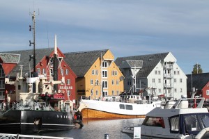
We drove north from Kilpisjärvi around 2 hours to Tromsö today.
More pictures: https://picasaweb.google.com/106188605401091280402/2012_09_14_tromso

We drove north from Kilpisjärvi around 2 hours to Tromsö today.
More pictures: https://picasaweb.google.com/106188605401091280402/2012_09_14_tromso
Some intense aurora borealis (northern lights) visible last night around 23:00. I stayed out watching and photographing until about 00:30 but it seemed the intensity was fading continuously while dark clouds also appeared.
As usual the camera sees a much more intense green, while the red is almost completely invisible to the naked eye (at least for me).
Here is a time-lapse video of all frames from last night.
Today we took a boat to the northwestern part of lake Kilpisjärvi. A 3km walk took us to the "Treriksröset" point where the borders of Norway, Sweden, and Finland meet. From there we hiked along the Arctic Trail 14km back to the research station along the shoulder of Malla. A lot of rain and some wind above 600m elevation.
Pictures: https://picasaweb.google.com/106188605401091280402/2012_09_11_jehkas
Climbed up Jehkas, 960m, today. Very cloudy/misty and a lot of wind at the top.
Pictures: https://picasaweb.google.com/106188605401091280402/2012_09_10_bollmannsveien
Hiked up and down Bollmannsveien("Ryssäntie") near Skibotn, Norway, today. Built by mostly Russian POW's in 1944 the road leads up the mountainside to an elevation of 555 m, overlooking the Storfjord.
Update: gps-trace with data and elevation curve in one picture
Update: pictures over here: https://picasaweb.google.com/106188605401091280402/2012_09_09_saana
I'm at the University of Helsinki's biological station at Kilpisjärvi, to do some hiking for a week.
The first day we climbed Saana.