- 1053 km running. (one marathon, one half-marathon, one 40k march). This is actually slightly down from 1133 km in 2010.
- 2924 km cycling. (five longer trips: 110k 108k 100k 106k+87k)
- 245 km cross-country skiing. (most of it during a week in Äkäslompolo)
- Rogaining: 12h/April and 24h/July
- Orienteering: 7 times (3/June Laakso Pornainen Ilola , 3/July Karjaa Pirttibacka Keimola, 1/October Kerava)
Category: Sport
GPX-routes with OpenLayers
I got a few GPX-tracks from last Friday's rogaining event and drew them with OpenLayers.
Over here: http://www.anderswallin.net/loppiaisrogaining2012/
OpenLayers has a nice set of examples online. Browsing and copy/pasting from examples is much better than trying to read & understand formal documentation.
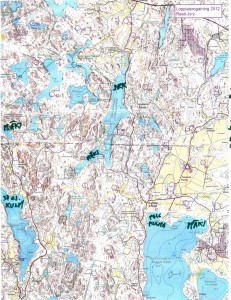
8h Rogaining, Espoo
Took part in an 8h rogaining event yesterday. Very wet in the forest with a lot of fallen trees due to the storms over the last few weeks.
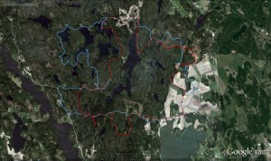
We planned a ca. 20km long route (straight lines between controls), assuming we would walk up to 50% more, i.e. around 30km, which would be OK for 8 hours.
This event had a 1:25000 map which was much easier to read compared to the 1:40000 one last fall. No problems in the beginning, we fould 23 -> 21 -> 31 -> 41 quite easily. The first digit of the control-numnber indicates how many points you get for the control. The next control 51 was worth five points, and they are usually harder to find. Not this time, since it was at the very top of a hill, and people before us had already left tracks in the snow.
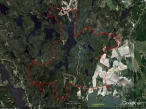
Then comes the big mistake of the day. We follow another faster group west down the hill from 51 towards 32. For some inexplicable reason we then completely mis-place ourselves on the map and although we are practically within reach of 32 we make a slow detour south before we realize where we are. Update: I have since learned that our confusion most probably was caused by a brand new road in this area, which was not marked on the map!
Probably annoyed by the first mistake, the second mistake of the day comes on the very next control: between 32 and 37 we take the wrong path north-east and decide to head back when we realize that.
So far we had stuck to the plan, but looking at the watch at 37 we decided to cut 39 from the route. Walk north along the road to 26, and then more walking along a big and then a small road to 57. At 57 we had some discussion about whether to walk back along the road, or try to find the electric lines north of 57 and let them guide us to the road. We had used 4 hours, or half of the total time here. We chose the latter route, and a straight northward pointing bit of our path after 57 indicates where we walked under the electric lines. Close to 53 the plan was to follow a path to the right of the hill and then the ditch to the control. Things didn't go to plan and we ended up to the left of the hill, but found the control with the help of tracks in the snow and voices/lights of others. A walk along the lake-shore to 55. And further north to a road.
So far we had roughly followed the plan. But now we had less than 3 hours left, and it was already dark making orienteering in the woods without clear paths or roads much harder. We decided to forget the plan and walk mostly along roads towards the finish, taking controls close to roads/paths along the way. A long bit of walking first south and then northeast to 49. Another long bit of walking all the way to 24. Here the image shows double GPS-paths because I switched from the 405cx watch to the Edge800 I use on the bike. We still had 45-50 minutes left at 24, so with a close eye on the clock we find 33 quite easily and 22 with a little more effort. We finished with about 12 minutes to spare.
About 90 teams (either solo, or in teams of 2-4 persons) took part.
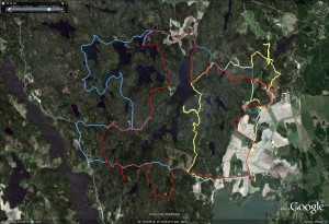
Update, here's our route again (in red), compared to another slightly faster team's route in blue:
Tuesday Ten
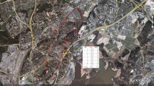
Another Nokia N9 vs. Garmin GPS test
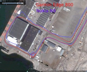
These results are much like my previous ones. Close to buildings or other difficult places the N9 GPS performs significantly worse than the Garmin. This is somewhat surprising since the N900 performs very similar to a Garmin. Could better GPS-data on the N9 be just a software-update away? When is someone going to try to get TJ Lindfors's RTK-GPS Openmoko hack to work on the N9 ?!
Nokia N9 vs. Garmin Edge 800 GPS Test
My legs aren't exactly recovered from Saturday's marathon, but a slow 5k jog anyway today. Sports Tracker was released for the N9 last week (or was it earlier?), so I thought I'd do some GPS testing. Held Garmin Edge 800 in my right hand and the N9 in my left. The results aren't that great for the N9:
I should do a test on the bike later. Maybe include the Garmin 405cx and older C7 phone also?
The touch-screens on these devices are different: Edge 800 works fine with gloves, N9 doesn't work at all with gloves.
Rautaveden maraton
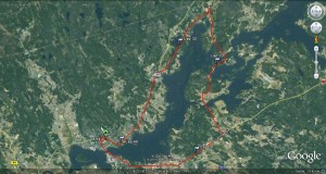
Rautaveden marathon, the last 'big' marathon in the Finnish running calendar, loops around lake rautavesi around 50km west of Tampere. Rogaining and biking earlier in the fall together with a week of flu meant that it was either this event, or possibly Åland a week earlier (but that would have been more of a hassle travel-wise).
The first 9k of the route is quite flat and takes us out of the city and onto the big Tampere road. Almost the whole 9-10 km interval is a big uphill which resulted in a slowish 5m:50s kilometer-time. After that it's a bit of downhill and varied terrain until around 19k (after ski-resort Ellivuori) where there is a big downhill. For me a fast kilometer-time of 5:02 - but as I haven't practiced running downhill much I think my legs got beat in that downhill pretty bad. After that it's more flat/varied until the turn at the top of the map around 26k. This is where my legs were about finished 🙂 I then walked most of the steeper uphills, and some flat-bits too during each kilometer between maybe 32k and 39k. At the end after the last drinking-station at 40k I ran again all the way to the finish for a time of 4h 12min 40s - a new personal best, but not the sub-4h I had maybe hoped for...
Splits for the first and second 20k:
1-20k: 1:49:51 (5:30/km)
21-40k: 2:06:50 (6:21/km)
Or broken down into 10ks: 59min, 2nd 62min, 3rd 67min, and 4th 76min.
1-10k: 54:59 (5:30/km) (HCM: 59m)
11-20k: 54:52 (5:29/km) (HCM: 62m)
21-30k: 1:00:06 (6:01/km) (HCM: 67m)
31-40k: 1:06:44 (6:40/km) (HCM: 76m)
Or broken down into 5ks, and compared to last year's Helsinki City Marathon:
1-5k: 27:13 (5:27/km) (HCM: 29m)
6-10k: 27:46 (5:33/km) (HCM: 30m)
11-15k: 27:29 (5:30/km) (HCM: 30m)
16-20k: 27:23 (5:29/km) (HCM: 31m)
21-25k: 28:57 (5:47/km) (HCM: 33m)
26-30k: 31:09 (6:14/km) (HCM: 34m)
31-35k: 31:27 (6:17/km) (HCM: 36m)
36-40k: 35:17 (7:03/km) (HCM: 40m)
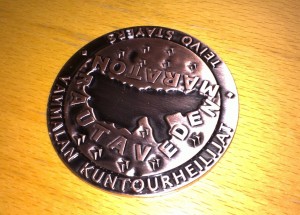
Finally the all important medal:
A comparison of the elevation-graph from the organizers website with data from my garmin 405cx. The heart-rate graph clearly shows how hitting "the wall" at 32k results on walking-breaks and a lower heart rate.
![]()
Sunday long run
25k in 2h 40min (avg pace 6:25/km) with avg HR 139. This is about the longest training run I will do in preparation for a marathon - I think. Some training programs advocate increasing the long-run distance up to 30k and above, but many others claim the risk of injury or overtraining increases dramatically when doing 3+ hour training runs and thus they are not worth the risk.
